Over the last week or so, Northern Texas, most of Oklahoma, and Southeastern Kansas have seen the brunt force of a tornado outbreak.
In 2011, one of the worst tornado outbreaks in Alabama history hit there just over 13 years ago. These are two pretty different places in the United States, so what causes these differences in the areas that these weather patterns occur in?
To start out, we can look at the el nino, and la nina patterns. “We see the origin of the name el nino, going back to its original meaning of ‘the child.’ This is because these events were always noticed around Christmas time, and they named it ‘el nino’ after Jesus, said Brian Adam, who is a meteorologist at the National Weather Center in Charleston South Carolina.
The el nino starts from the warning, and the cooling of the waters in the Pacific Ocean. The pattern was noticed by the natives of the polynesian islands in the Pacific Ocean.
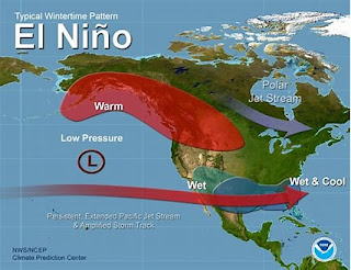
You are probably wondering how this affects our weather here in the continental United States.When the water begins to warm up, this causes the temperature in the atmosphere to rise as well, this causes the warm air to be pushed up, and pushes up the jet stream.
Typically severe weather happens along the jet stream, and if it is pushed further up, that means that there are many more tornado active situations in the northeast about this time of year.
This is just the opposite in the la nina years and times, this means that the waters in the Pacific Ocean are cooler, meaning that there is cooler air in the atmosphere that leaves room for the jet stream to do as it wills, and typically that means that the jet stream pushes further south, leaving room for more tornadic weather in the south during the spring season.
Tornados in the United States are typically formed in what is known as “tornado alley.” This is the area that is most known for tornadoes. Tornado alley used to reach from North Texas, through the great planes, but has recently shifted further east, and affects areas such as Arkanasa, Mississippi, and Alabama. Parts of north central Florida are also well known for tornadoes as well.
Tornadoes start from a warm air mass, and a cold air mass meeting. When this happens the cold air mass and the warm air mass begin to almost fight with each other, and spin around in the atmosphere, this causes the circulation of the air, which forms a tornado.
https://images.app.goo.gl/BdTR4dFVEZ2yhZ3f6
Typically this warm air mass comes from the gulf of Mexico, and makes its way up into the continental U.S. When this meets with a colder air mass from the Rocky Mountains, that is the perfect recipe for tornadoes to begin.
And once again, it really does matter where that jet stream is located, if it is further north in el nino, this means that the tornadoes will typically be further north, and the opposite with la nina.
Tornado alley seems to have moved further east.This means that there are some things that are ramping up a little bit more in places like Alabama, and such this can be due to a warm air mass shifting things further east.
In an article written by Allison Finch who is a staff writer a accuweather, finch writes that “The term tornado alley was coined in 1952 when two meteorologists studied severe weather in parts of Texas and Oklahoma.” said Finch
Meteorologist Paul Pastelok attributed the eastward shift of tornado alley to the lack of moisture in the area. This is pushing the weather further to the east. Most of the time you do not see bad weather come without rain, like tornadoes. It has happened in the past, but it is very unusual.
We are currently in the process of a regressing el nino, this means that by next year, the la nina will more than likely be taking effect. This means that you can probably expect tornadoes that are further south towards the spring of next year. In the meantime however, the southeast is going to get a break from the severe weather in the area.

